We at the Royal National Lifeboat Institution (RNLI) are immensely proud to have won a top IT industry award for the Best Charity Project of the Year, in recognition of our vital lifesaving work.
The UK IT Industry Awards set the performance benchmark in IT, recognising exceptional people, projects, and technology innovation.
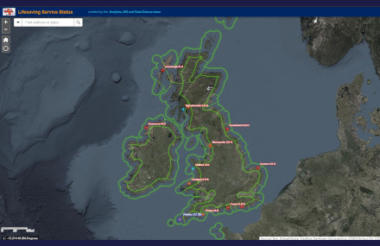
So it was fantastic to learn that our geographic information system (GIS) to help improve the management of the RNLI’s fleet of 460 lifeboats and more than 1,500 lifeguards around the UK and Ireland was recognised by the judging panel as "outstanding" and deemed good enough to see us crowned winners in the third sector category for charities.
Lead judge and head of content and Insight at the British Computer Society – the Chartered Institute of IT - Brian Runciman said: "This project boasted a balance between innovation, return on investment, quality of management and impact that alongside its obvious societal benefit made it truly outstanding."
In simple terms, the mapping tool incorporates data showing lifeboats that have been requested to launch, their live position as well as off-service lifeboat stations, with the same information also available for the RNLI’s lifeguard units, giving a real-time and accurate operational picture of our overall lifesaving capability.
This has proved critical during the Covid-19 pandemic, allowing the RNLI to maintain its 24/7 lifesaving service by reacting quickly if any lifeboat stations or lifeguard units are taken off-service or involved in extended searches and rescues.
The RNLI is a vast lifesaving operation with 238 lifeboat stations on call 24/7, 365 days of the year around the UK and Ireland and in a ‘normal’ year, lifeguards on approximately 240 beaches throughout the summer.
'An effective, timely system'
The Central Operations and Information Room (COIR) team was established in 2019 with the challenge to provide an effective, timely system for reporting and recording the availability of our lifeboats and lifeguards, and a shared, real-time information picture.
The solution was developed using existing applications that were already in use in the RNLI, but which had not previously been brought together into one user-friendly system.
The complex nature of the project required 10 teams working closely together across the RNLI to ensure it worked flawlessly from end-to-end, and the strong relationships built as part of the project are still in place, with teams maintaining regular contact to monitor usage and performance of the tool, as well as sharing challenges and approaching new opportunities together, which is great to see and an added benefit.
Carolyn Bill, head of lifesaving support, said: "The national award was the result of the incredible teamwork.
"I am so proud of all the COIR and data teams for their commitment to the service and each other in enabling us to be recognised outside our own organisation."
Our new GIS mapping capabilities provide a greater situational awareness of our fleet for the COIR Team and has improved reporting and data quality, helping us work more efficiently as a lifesaving organisation.
Although originally designed as a tool for the Lifesaving Operations department, this information is now also available to a variety of teams across our charity, from engineering to communications and local and regional management.
Chris Chambers, a senior lifesaving operations room manager, describes the new system as "a game changer" for the RNLI adding: "It is having a tangible lifesaving benefit by allowing us to manage our lifeboat fleet far more effectively than ever before. It’s a huge step forward."
And that for us is what it is all about at the RNLI – saving lives at sea.
Dr Sam Prodger is GIS, data science & coast risk manager for the RNLI and project technical lead
Related articles


